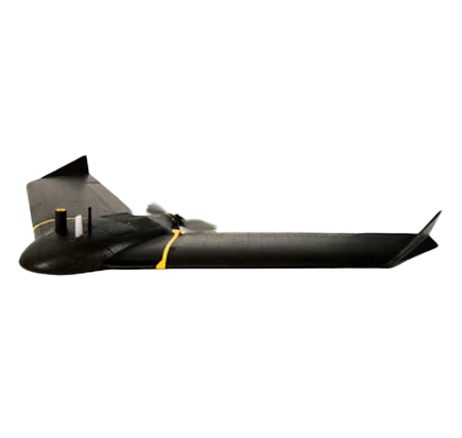
Lightweight regulatory compliant mapping drone
The eBee X is our most advanced fixed-wing drone that’s designed to meet all your surveying and mapping needs. Whether your project site is small or vast, straightforward or complex, the eBee X goes the distance while helping you boost the quality, efficiency and safety of your data collection.
The eBee X was designed to reduce both delays and repairs thanks to its modular design that lets you swap out parts, as needed.
- Overview
eBee X is compatible with a wide range of interchangeable photogrammetry cameras that capture reliable aerial imagery – from 3D models to orthomosaics – to suit every mapping job.
With the on-demand RTK / PPK capabilities of survey drone eBee X, you can gather data without ground control points (GCPs) while maintaining a GSD down to 1.5 cm / 0.6 in.
Operate safely within more regulatory frameworks thanks to the eBee X’s light weight, which extends your operational possibilities – BVLOS and flights over people – and range.
eBee X has the best ratio energy / MTOW compared to heavier VTOLs.
Efficiently map up to 500 ha / 1,235 ac while flying at 120 m / 400 ft eBee X flight time of up to 90 min* makes it the perfect drone for covering large areas.
RTK and PPK allow you to ensure more reliability with the accuracy obtained, without ground control points. The eBee X professional drone is compatible with the industry’s leading base stations.
Our R&D engineers have designed a shock absorbent drone fuselage with an underbelly made of reinforced polypropylene woven mesh.
We’ve prepared for U.S. and European drone regulations with eBee X, featuring built-in FAA-approved Remote ID and EU C2 and C6 labeling.